Mount San Jacinto

Lately I’ve felt the need to take a break every 3-4 weeks.  Working daily is mentally draining.  Call it burn out or compassion fatigue, either way I need a recharge.  I realized that I don’t necessarily need a long getaway to recharge, I simply need a day in nature to allow the weight to fall off my shoulders.  After the exhilaration and serotonin jolt I got from the Mt. Baldy hike, I quickly started to plan another hiking trip.

It’s amazing how little I’ve seen of SoCal after having been living here for the last 8 years.  Our lives have basically been confined to the 25 mile radius of our home.  On weekends we opt not to venture far from our home because we simply love staying in and near the area we live in.  Plus, the SoCal traffic is a huge deterrent to drive anywhere.  With that said, this year I’ve decided to take off a Friday every 3-4 weeks to explore SoCal.

To find another hiking trail, I consulted HikingGuy.com.  He has detail information and turn-by-turns on his website.  It’s a wonderful resource.  I wanted something challenging in an alpine environment.  In order to find that in SoCal, one must go up in elevation.  Meaning at least 8000 ft above sea level.  The best part about hiking in such high elevation in the summer is the temperature.  It could be 100F in the desert floor, but a cool 50-60F up top.

One interesting trail is the PS Tramway to Mount San Jacinto peak located in the San Bernardino Mountains in Palm Springs, which is about a 2-hour drive from Laguna Beach.

You take the Palm Springs Tramway up 6000ft from 2000ft.  The cost of the ride is $25, which is a pretty good deal if it can shave off 6000ft of ascent.

IMG_3641

The whole trip took 10 minutes, and the best part about the tram is that the floor rotates allowing you 360 degree view while you stand still in the tram.

IMG_3642

A view down toward the desert floor.

IMG_3646 (1)

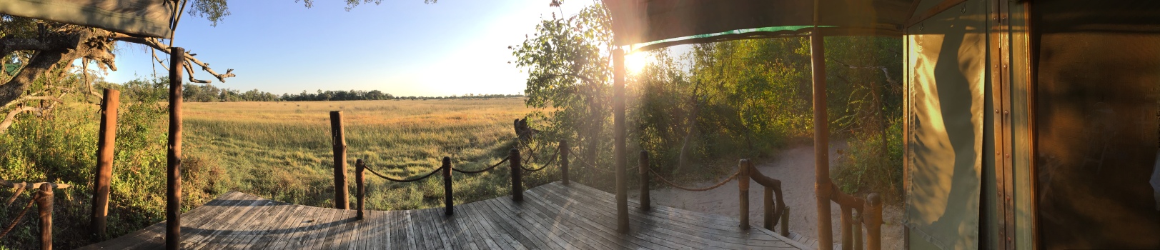
Once you get off the tram, you’re at 8000+ft and in alpine territory.

IMG_3650

IMG_3651

IMG_3654

Our goal was to reach the summit at 10,834 ft, which meant we still had a good 2600 ft ascent and 5.5 miles ahead of us.  Our first goal was to reach Wellman’s Divide at 9100ft.

IMG_3701

A view from Wellman’s Divide…

IMG_3665

After a quick water and snack break, we headed for the summit 2 miles away.

Found a nice cutout in a tree for a photo-op…

IMG_3671

Scenes along the way…

IMG_3678

You can see the desert floor to the left.

IMG_3683

There is still snow left at this elevation in June.

IMG_3684

IMG_3685

Near the summit, there’s a shelter with 2 bunk beds that you can stay at in case you’re caught in inclement weather.

IMG_3699

Judging by the sign, we took the easy way up.  Some people actually hike from the desert floor in Idyllwild.

IMG_3700

Luckily we brought hiking poles this time, because there was a patch of snow up the final push that made trekking tricky.

Finally made it up to the top after getting overtaken by a bunch of boy scouts…Ah youth…

IMG_3688

I read that on a clear day you can see Catalina Island off the coast of California to the west and Mt. Charleston in Nevada to the east.  Unfortunately, there was quite a bit of haze while we were up top, and chose to face east for our lunch break.

IMG_3693

After the half hour lunch break, we starting our hike back down…

IMG_3694

There was no way to hike down this without the use of hiking poles.

IMG_3695

The hike took us a total of 7.5 hours (plus the 1/2 hour break up at the summit).  It took 4 hours to go up and 3 hours down.  By the time we got back down to the desert floor, we were ready for some real food after a whole day of trail mixes.

When it comes to eating, it’s always Joe’s responsibility to find yummy food because it’s important to him.  After much researching prior to the hike, we decided on Workshop Palm Springs.

The restaurant has a very hip, minimalist, industrial feel.

IMG-3710

The Palm Springer cocktail was yummy!

IMG-3711

The octopus carpaccio was especially refreshing after a long day of hiking…

IMG-3713 (1)

and the mussels were to die for.  The broth was so good that we quickly accepted another round of buttered toasted bread in order to sop up the broth.  It would have been easier had they just offered us a straw each.

IMG-3714

I opted for the saffron risotto because I needed the carb for my scheduled 10 mile run the following day.

IMG-3715

Joe had the pork chop with amazing relish.

IMG-3716

Finally, the pistachio mouse with passion fruit gelatin, which unfortunately overpowered the pistachio.

IMG-3717

This hike was unique because of the tram, but not quite as interesting as Mount Baldy.  For now, we’re going to take a break from hiking as I think we got the hiking bug out of the system.  Luckily, we have a more sedate Vegas trip coming up in 3 weeks…

Mount Baldy

Hiking Mount Baldy was a last minute decision.  While at work on Friday, I was itching to go somewhere and do something over the Memorial Day Weekend.  Hiking is always fun, so I googled hiking trails in SoCal.  I didn’t want just any two-bit hiking trail like the ones we have in Laguna Beach.  I wanted something challenging, fun, and beautiful, which meant I had to look at higher elevation climbs.  Mount Baldy, AKA Mount San Antonio, fit the bill.

Mount Baldy is located in the Angeles National Forest, which is an hour and change north east of us.  Mount Baldy summit is the highest peak in LA county, topping out at 10,064ft.

After stopping off at the visitor center to pay for our $5 Adventure Pass we headed to Mankers Flat, the start of the trailhead.

There are 2 ways of getting up to the summit.  The Devil’s Backbone or the Baldy Bowl trail.  From Mankers Flat, we picked hiking up the paved road to Mount Baldy Resort, then hiking up the Devil’s Backbone Trail to the Summit.

IMG-3553

One thing that caught us off guard was the snow.  It had rained the night before, and any precipitation above 8K ft translates to snow.  I think had we known there was going to be snow, we would have scrapped the hike because we were warned not to hike the trail when there is snow.

However, snow makes this place look like a wonderland.  It’s beautiful beyond description.

IMG-3559

Some people opted to take the ski lift up to the resort before picking up the trail.

IMG-3561

A view above the clouds before the Devil’s Backbone Trail.

IMG-3564

Looking east towards the Mojave desert.

IMG-3572

The start of the Devil’s Backbone trail.  Called the Devil’s Backbone trail because you have sheer drops on either side of the path.  When icy, this is where people fall off to their deaths.

IMG-3575

Looking back at the hikers crossing the first section of the backbone.

IMG-3577

Hiking up towards the second section.

IMG-3578 (1)

Never would I imagine this kind of view existed in Southern California.

IMG-3579

Posing on the second section of the backbone.

IMG-3584

Certain sections are narrower than others.

IMG-3587

Immediately past the backbone, there was a narrow part that hugged the cliff wall.  Some of the snow had turned slushy and slippery, and at one point I thought I was going to fall off.  I think I would have been perfectly fine had there not been any snow on the ground.  This is when a set of hiking poles, and some crampons would come in handy.  I just remember digging my nails into the side of the wall to keep me from falling.

I had never been so scared in my life.  Even Joe said he’s never seen me so frightened.

At the bottom of the last summit.  This part was hard only for the fact that it was freezing and the wind was whipping at top speeds, and we had no where to hide.  This section was completely exposed.  Joe couldn’t feel his lips.  I just felt stinging on the right side of my face as the wind was coming from that direction.

IMG-3592

As we were hiking, we both had the same thought about turning around (a group had turned around).  However, for me, the thought of having to go back to the narrow path where I thought I had almost fallen off made me push forward.

We finally made it.  Four and a half hours and 4000 ft from the parking lot, we made it to the summit.  The last section took us a good 40 minutes to hike up.

IMG-3598

Thanks to the gale force wind, we chose not to linger at the top, and we made our way down the Baldy Bowl trail.

IMG-3604

Breathtaking!

IMG-3605

Can’t remember the last time we saw snow.  This was an impromptu thing Joe did.  He just plopped down to make a snow angel.

IMG-3607

Luckily, the Baldy bowl trail was protected from the wind, and we decided to have our mid-day snack here while enjoying the view.

IMG-3608

View along the trail at lower elevation.

IMG-3609

Finally, at the end of the Baldy Bowl trail which connects to the paved road we had hiked up 7 hours ago.

IMG-3612

I am so glad we did this impromptu hike.  Granted I almost died of a panic attack, but it was worth it.  Would I do it again?  Absolutely, but only after the snow has melted, and after investing in some good hiking poles.

Lesson Learned

I get the daily NYT news alert featuring “California Today” – features and stories that matter to Californians.  This past Friday’s “California Today” featured Borrego Springs, a Dark Sky community that draws stargazers thanks to the low light pollution levels.  It’s also known for it’s quirky metal sculptures, the work of Ricardo Breceda, scattered around town.  Since it’s a couple hour drive from where we are, I decided last minute that we would take a day trip out there this weekend.

Ideally, we should have left first thing in the morning so that we could spend most of the day there.  However, we had to get our regular exercise in – one hour with our personal trainer, and another 45-minute run for me, and an hour of BJJ for Joe.  This meant, we didn’t get to leave until 2PM.

The drive ended up being 2.5 hours given the usual traffic on the 5.  By the time we got to town, it was 4:30PM.  We had about an hour and a half of daylight left to check out the sculptures.

First stop was the Mammoth.  This was the only spot where we got sunlight.

DSC_1158

Next up were the dinosaurs.  The sun had already dipped behind the mountains.

DSC_1171
T Rex

DSC_1162

DSC_1168
The car offers a perspective to the size of these sculptures.

We hit the Scorpion and the Grasshopper next.

DSC_1176

DSC_1175

For the star of the show – The Serpent.

DSC_1191

DSC_1192

Unfortunately, there were a whole bunch more sculptures we had to bypass as we were short on time.

Since we didn’t have to wait long for night fall, we stuck around for some stargazing.  We had never seen so many stars in our lives.  When we lived in NYC, the only celestial object we could see was the moon.  Tucson opened up our eyes to starry nights, and I routinely got the chance to trace out the big dipper and Orion’s Belt, but we never could make out the Milky Way.

Borrego Springs is on a whole other level.  The sky is FULL of stars, and we got to see the Milky Way for the first time in our lives!

Of course I had to attempt shooting the stars.

Here’s a screen grab of the NYT photo of the Milky Way in Borrega Springs…

Here’s my shot of the Milky Way…

DSC_1216

EPIC FAIL!  Talk about ‘photo does not do justice’.

I could not for the life of me figure out how to sharpen the image, other than shortening the shutter speed, but then I wouldn’t get enough light.  Increasing the ISO only made the image too grainy.  The specs for this epically bad photo was ISO 6400, 10mm, shutter speed of 30 secs.  Using the ‘500 rule’ (500/focal length, which in this case is 10mm), my shutter speed should have been set @ 50 secs, but my camera ‘does not go there’.  Later I realized that my settings should have been ISO 3200, 24mm, shutter speed of 20 secs.

Oh well, next time…


Fall @ Home

Joe and I were debating which season is our favorite.  Being in SoCal, we really don’t get 4 seasons, or at least it’s not as apparent as it is in the Northeast.  However, after having lived here for 7 years we’ve picked up on the subtleties of changes in seasons – we do in fact have 4 seasons, albeit a change in a few degrees, humidity, colors of the surroundings, and crowds in town.  Yes, we do get cold when it hits 60, and the cashmere sweater does make its appearance in 50-degree weather.  I don’t really care for temps under 60 these days.  Call me soft.  Call me a wimp.  But ideal temp for me is 68-78 degrees.  And when you live in paradise, that’s what you get.

Being fall, I decided to change up the décor in the living room.  I switched out the orange pillows with white and grey to welcome the fall/winter season.

DSC_1144[1]

Our lovely neighbor just gave us a white orchid this evening, and it matched perfectly with the white pillows.

DSC_1152[1]

DSC_1147[1]

The dog making his appearance…

DSC_1145[1]
The wide angle lens is able to capture the entire living room in the frame.
Fall is in fact my favorite season in SoCal.