Fired47.Wordpress.com for our post retirement travels.
Maui – Day 4
Today’s the big day. I decided to skip the morning conference so that we could get a jump on our drive to Hana. The main objective of this trip was to get a better picture of the rainbow eucalyptus tree (we saw this on the roadside back in 2016, but didn’t get a good photo of it as we just drove right by it), check out the black sand beach, and hike the pipiwai trail to see the bamboo forest. I’ve always wanted to see the bamboo forest ever since I saw a photo of it at a gallery years ago.
The plan was to leave the hotel at 6AM so that we would reach Kaenae Arboretum (for the rainbow eucalyptus trees) by 8AM and then grab some banana bread for the hike at Aunty Sandy’s when they open at 8:30AM. We ended up making real good time, but missed the stop for the arboretum and got to Kaenae point, where Aunty Sandy’s is, before 8AM. We walked about checking out the scenery and waited for Aunty Sandy’s to open.

After getting the provisions, we doubled back to find the arboretum, which luckily was just right before the turn for Kaenae Rd. There were 2 small parking spots around the bend, and easily missed if one drove too fast, which is what happened to us (slow down once you pass the 16 mile marker and the YMCA to your left). Once parked, we crossed the highway to enter through a cattle gate. The walk was about a half mile on paved road before we reached the big Chinese bamboos, then it was a short walk on trail to get to the eucalyptus trees.

The colors are formed when the bark peels away.

We were told that depending on the season, the colors would vary. Some would have blues, purples, and reds. We only got to see orange, lime, and dark green.

Once I was satisfied with my photos we were off, but not without stopping for photo ops of the waterfalls along the way.

There were a couple of places where we could actually stop and park, but a lot of the waterfalls were only to be viewed as we drove by as no parking was allowed.
We almost missed the turn for Wai’anapanapa State Park where the black sand beach is located (again, drove too fast).

Here’s a view of it from the walkway above the beach.

You’ll need to take a flight of stairs down to the beach, and right at the bottom of the stairs to the right there’s a opening to a small cave.

The black sand is formed from lava rocks.

Personally, I still prefer the powdery white sands you’ll find in the Caribbeans, but this was interesting to see.

Finally, we were off to the hiking trail, but not without stopping for another waterfall.

By the time we got to Haleakala National Park (where the Pipiwai trail is located in), it was approaching noon (5 hours after we had left the hotel) and we had already polished off 1 loaf of banana bread (Joe ate most of it), and the coconut chew (I practically had all of it). The entrance fee was $30 per vehicle, which was higher than the usual NP entrance fees, but what are you gonna do? Turn around and call it a day?
There are 3 trail heads starting at the visitor center. The Pipiwai trail is a 2-mile trail that ends at the Waimoku falls. The Ohe’o Gulch trail is a 0.5 mile loop trail that brings you to the seven sacred pools, which was closed to swimming the day we went due to strong water flow from all the rain. The Kuloa Point trail is another 0.5 mile coastal loop trail.
We decided to hit the Pipiwai trail and then the Ohe’o trail afterwards.
The initial section of the trail wasn’t as shaded, but we got some respite as soon as we got to the bamboo forest thanks to the dense cover.
Here’s the entrance into the bamboo forest after crossing the foot bridge.

Here’s a set of falls at the foot bridge. Water was murky due to the volume of rushing water churning up the sediment.

This is the view as soon as you cross that bridge and enter the bamboo forest.

My photos didn’t turn out like the ones I saw at the gallery, and that’s why my photos are not displayed in galleries.


We spent a good deal of time hiking through the bamboo forest. The key was to keep moving, otherwise we’d be eaten alive by mosquitos. Once through, this was the view that welcomed us.
Waimoku falls…

Unfortunately, we couldn’t continue past the warning sign to get to the base of the fall. People have died in the past from falling rocks when they got too close.

More photos of the bamboo forest on the way back.


We had passed this huge banyan tree on our way up, but since kids were playing around and climbing the branches we decided not to stop for a photo op. However, on our way back there were very few people, and I managed to capture this to show the immense size of the tree. If you look closely, some of the prop roots (dropping down from branches) are as thick as a grown man.

Note, in order to get the entire tree in the shot you’ll need a wide angle lens. Phone cameras will not be able to capture the whole tree, unless you do a pano, but we all know that panos tend to distort the image.
It took us about 2-3 hours to finish hiking the pipiwai trail, and then it was on to the Ohe’o Gulch loop.
Thanks to the swift current, we were not able to swim in the pools – we had worn our bathing suits for nothing. The greatest concern was getting washed out to sea where the great sharks await.

If only we had developed suction discs on our bellies like the Oopu.

A close up of the waterfall.

By the time we were done, it was time for ‘lunch’. We had polished off the last loaf of banana bread. We had seen a huli huli chicken place at Koki beach on our drive in, so we decided to check that out.
One of the reasons why it takes hours on the road to Hana is because of all the winding narrow roads with one lane bridges. Combine that with cautious slow drivers up ahead, you’re looking at a whole day spent in the area. However, you also don’t want to be the first car, because then you’ll become the slow driver watching for oncoming cars. On our way back, we were stuck behind someone driving 10 miles an hour. The locals behind us got impatient and yelled at us to pull aside. I let him pass and when he got to pass the slow driver I followed closely. The local obviously knew the roads well and I felt comfortable enough to follow him and go as fast as he did. It didn’t hurt that I’m used to driving winding roads all the time. Just wish we were in our own car that eats curves instead of our rental Toyota Corolla.
Thanks to the local driver, we got to Koki beach in no time. This guy has his huli huli chicken stand right on the beach. Chicken was good, but it was mostly for the experience of eating lunch from a chicken stand on the beach.

Towards the end of our meal it started to rain, and all of us were running for cover with our plates of chicken. It was actually quite a hilarious sight.
For dessert we had ice cream at Coconut Glen’s located at mile marker 27.5. Ice cream was less creamy, more gritty. Interesting tastes, but hard to pinpoint the exact flavors.

Finally, we made a stop under the same tree we had stopped at 4 years ago just to duplicate the pose…

Back in 2016…

By the time we got back to the hotel, it was well past 7PM. We had spent 13+ hours on the road, but it was all worth it. We were too beat to go out for dinner and called it a day.
Maui – Day 3
Another morning consumed by conference. As for the afternoon, we planned ahead of time and brought our hiking boots with us to checkout the Iao Valley State Park.
Lunch was at Tin Roof. We had planned to hit this joint after landing in Maui 2 days ago, but they close on Sundays. I had high hopes for this place because Joe read good reviews, but it was just good, not fantastic.

Iao Valley Park is located in the Waikulu area close to the downtown area so it was a short drive to the park. We quickly learned that we could avoid the park fee by parking alongside the road outside the park entrance.
One thing you’ll notice on the island is that wild chickens are everywhere – at gas stations, grocery store parking lots, and of course in state park parking lots.

A view from the parking lot…

We thought we needed hiking boots, but this was completely doable in flip flops as the trail was mostly paved. You can climb a flight of steps to get a closer look of the Iao needle.

Then there’s another trail bringing you closer to the creek.

Both trails were very short and we were disappointed that that was it. However, we quickly realized that there were trails leading away from the designated trail and decided to check them out.

Found a rope tied near a pool of water, and it was very tempting to jump in, but I didn’t have my swim suit with me, so I opted for the next best thing – posing with the rope pretending to swing into the pool.

We started to encounter denser brush, and I was getting a little concerned that we may get lost and end up needing to be rescued like those missing hikers I had read about a few months ago. When we came upon a couple who were heading towards us, I asked if there was anything to see further up, and was told that there were no waterfalls up ahead and it was just the same dense trail. So we turned around.
Checked out the rest of the paved trail and managed to position myself (by going past a warning signage) to get a nice shot of the Iao Needle with Joe standing on the bridge.

Since this park visit was literally a walk in the park we had ample time to kill. We decided to head back to the hotel and do beach stuff. Unfortunately, the waves were just too strong that we couldn’t really do much.
The beach was pretty much deserted.

We did try our best to stay for sunset, but the sandblasts won.

When in Hawaii, one must have Hawaiian ice, even though it’s just sugary syrup on ice.

Dinner was at Miso Phat again…

Maui – Day 2
With conference taking up the entire morning, we only had the afternoon to check out the island.
Lunch was at Aloha Mixed Plate in Lahaina. I had the shoyu chicken which tasted very similar to something I’ve grown up eating. Joe had the Mochiko chicken, which he wasn’t too impressed with. The view however, was great.

I was debating between going for a hike at the Iao Valley park or checking out Wailea/Makena, but since I didn’t have the proper footwear (again), we opted for the Wailea area last minute.
Here’s one of my favorite stretches on Honoapiilani highway. Love the tree canopy!

There wasn’t much in Wailea except for some real high end luxury resorts and the Makena public beach at the end of the road.


Since lunch was huge, we opted to skip dinner, but we did stop for pie at Leoda’s. We wanted to get the guava chiffon pie, but that was sold out – we tried again the next day without success, but did finally get it the morning we flew out (we sat outside curbside before going through TSA, enjoying the pies while appreciating the Maui mountain views).

Pies were good – a bit too sweet for our palate, but this is the place to go if you love mousse pies.
Maui – Day 1
Our first time in Maui was in 2016 with mom and dad. Due to the fact that they were with us, and dad had some medical issues at the time we really didn’t get to explore the island as much as we wanted to. This time around I made sure we hit everything we wanted to see, specifically to hike the Pipiwai trail to see the bamboo forest. We also finally got a chance to go whale watching for the first time.
As soon as we landed we decided to get some authentic Hawaiian food. We ended up at Poi by the Pound that was within walking distance from our car rental company SIXT. We actually didn’t realize it was within walking distance, and ended up driving around the block.
Joe and I shared the Hawaiian plate which consisted of kalua pork, lau lau, poi, chicken long rice, ahi poke, and salmon lomi. This gave us a chance to taste all the various local dishes. My favorite was the kalua pork, but due to it’s saltiness I ended up mixing it with poi, which by itself is rather bland. However, the combo was actually pretty tasty.

After lunch we were on our way to our hotel – the Kaanapali Beach Hotel (the same one we stayed at 4 years ago). I decided to stay at KBH due to it’s proximity to the Sheraton where the conference was being held. The other reason why I picked KBH was that they do not charge a resort fee like all the other hotels. Personally, I don’t like paying for resort fees as they really don’t add much value to my stay – I don’t need wifi and free local calls, as that’s was a personal cell phone is for.
Instead of driving clockwise from Kahului to Kaanapali like we did last time, we opted to drive counterclockwise to check out the part of the island we didn’t get to see last time. The clockwise route is a major thoroughfare between Kahului and Lahaina, whereas the counterclockwise route is a one-way winding route that is slower, but much more scenic.

The cloud cover lifted as we continued on.

The one thing I love about Hawaii is how lush and green everything is, especially the windward side of the island.

The contrast of the green mountain and blue ocean.


Imagine living in a place like this. Terribly inconvenient, but you’re in your own paradise.

One thing we’ve learned over the years, is that if you see a bunch of cars parked on the side of the road – stop, and check it out. This is what we were awarded with after a 2-minute trek on the trail.

Getting closer to the ledge, at risk of getting blown over.

It was really windy the week we were there as you can see from the waves being picked up by the wind.

A closer look.

Interestingly, there are no signs along the road pointing out scenic vistas. One of them being the Nakalele blowhole I’ve wanted to check out last time. The only reason why we ended up at the blowhole this time was all thanks to the telltale sign of a huge gathering of rental cars. We didn’t even know what we were stopping for until we saw this sign on the trail.

One other thing we’ve learned over time is to always heed warning signs. So we steered way clear away from the blowhole – maybe we stayed a little too far. The other reason for not hiking all the way down was due to the fact that I was wearing flip flop sandals, which was not the most appropriate footwear for the situation.

With all the stops along a narrow winding road, we finally reached the hotel some time after 4PM. As soon as we dropped off our bags, we headed over to the Whalers Village to pick up one of my favorites – Honolulu Cookies, to bring back to the office after the trip.
Caught a rainbow on our way back to the hotel room.

For dinner, we opted for sushi since we hadn’t had sushi in years despite the fact that we live in California. We opted for Miso Phat given that they get their fish same day off their own boat “Shiso Phat”, and let me tell you the fish is absolutely fresh and delicious, especially their hamachi. I can’t remember the last time I had such good sushi other than back in 2009 at the Tsukiji Fish Market in Tokyo. In fact, it was so good that we ended up having dinner there 3 nights out of the 5 – we would’ve gone 4 had it not been for our 13-hour Hana highway trip that drained us by the time we got back to the hotel in the evening, and we opted to skip dinner all together.
If you ever end up at Miso Phat, make sure to order the Miso Phat roll, TNT roll, and spicy hamachi roll. Also the joint doesn’t have a liquor license, so BYOB (there’s a deli next door that sells good Japanese beer and sake).

Mount San Jacinto
Lately I’ve felt the need to take a break every 3-4 weeks. Working daily is mentally draining. Call it burn out or compassion fatigue, either way I need a recharge. I realized that I don’t necessarily need a long getaway to recharge, I simply need a day in nature to allow the weight to fall off my shoulders. After the exhilaration and serotonin jolt I got from the Mt. Baldy hike, I quickly started to plan another hiking trip.
It’s amazing how little I’ve seen of SoCal after having been living here for the last 8 years. Our lives have basically been confined to the 25 mile radius of our home. On weekends we opt not to venture far from our home because we simply love staying in and near the area we live in. Plus, the SoCal traffic is a huge deterrent to drive anywhere. With that said, this year I’ve decided to take off a Friday every 3-4 weeks to explore SoCal.
To find another hiking trail, I consulted HikingGuy.com. He has detail information and turn-by-turns on his website. It’s a wonderful resource. I wanted something challenging in an alpine environment. In order to find that in SoCal, one must go up in elevation. Meaning at least 8000 ft above sea level. The best part about hiking in such high elevation in the summer is the temperature. It could be 100F in the desert floor, but a cool 50-60F up top.
One interesting trail is the PS Tramway to Mount San Jacinto peak located in the San Bernardino Mountains in Palm Springs, which is about a 2-hour drive from Laguna Beach.
You take the Palm Springs Tramway up 6000ft from 2000ft. The cost of the ride is $25, which is a pretty good deal if it can shave off 6000ft of ascent.

The whole trip took 10 minutes, and the best part about the tram is that the floor rotates allowing you 360 degree view while you stand still in the tram.

A view down toward the desert floor.

Once you get off the tram, you’re at 8000+ft and in alpine territory.


Our goal was to reach the summit at 10,834 ft, which meant we still had a good 2600 ft ascent and 5.5 miles ahead of us. Our first goal was to reach Wellman’s Divide at 9100ft.

A view from Wellman’s Divide…

After a quick water and snack break, we headed for the summit 2 miles away.
Found a nice cutout in a tree for a photo-op…

Scenes along the way…

You can see the desert floor to the left.

There is still snow left at this elevation in June.


Near the summit, there’s a shelter with 2 bunk beds that you can stay at in case you’re caught in inclement weather.

Judging by the sign, we took the easy way up. Some people actually hike from the desert floor in Idyllwild.

Luckily we brought hiking poles this time, because there was a patch of snow up the final push that made trekking tricky.
Finally made it up to the top after getting overtaken by a bunch of boy scouts…Ah youth…

I read that on a clear day you can see Catalina Island off the coast of California to the west and Mt. Charleston in Nevada to the east. Unfortunately, there was quite a bit of haze while we were up top, and chose to face east for our lunch break.

After the half hour lunch break, we starting our hike back down…

There was no way to hike down this without the use of hiking poles.

The hike took us a total of 7.5 hours (plus the 1/2 hour break up at the summit). It took 4 hours to go up and 3 hours down. By the time we got back down to the desert floor, we were ready for some real food after a whole day of trail mixes.
When it comes to eating, it’s always Joe’s responsibility to find yummy food because it’s important to him. After much researching prior to the hike, we decided on Workshop Palm Springs.
The restaurant has a very hip, minimalist, industrial feel.

The Palm Springer cocktail was yummy!

The octopus carpaccio was especially refreshing after a long day of hiking…

and the mussels were to die for. The broth was so good that we quickly accepted another round of buttered toasted bread in order to sop up the broth. It would have been easier had they just offered us a straw each.

I opted for the saffron risotto because I needed the carb for my scheduled 10 mile run the following day.

Joe had the pork chop with amazing relish.

Finally, the pistachio mouse with passion fruit gelatin, which unfortunately overpowered the pistachio.

This hike was unique because of the tram, but not quite as interesting as Mount Baldy. For now, we’re going to take a break from hiking as I think we got the hiking bug out of the system. Luckily, we have a more sedate Vegas trip coming up in 3 weeks…
Mount Baldy
Hiking Mount Baldy was a last minute decision. While at work on Friday, I was itching to go somewhere and do something over the Memorial Day Weekend. Hiking is always fun, so I googled hiking trails in SoCal. I didn’t want just any two-bit hiking trail like the ones we have in Laguna Beach. I wanted something challenging, fun, and beautiful, which meant I had to look at higher elevation climbs. Mount Baldy, AKA Mount San Antonio, fit the bill.
Mount Baldy is located in the Angeles National Forest, which is an hour and change north east of us. Mount Baldy summit is the highest peak in LA county, topping out at 10,064ft.
After stopping off at the visitor center to pay for our $5 Adventure Pass we headed to Mankers Flat, the start of the trailhead.
There are 2 ways of getting up to the summit. The Devil’s Backbone or the Baldy Bowl trail. From Mankers Flat, we picked hiking up the paved road to Mount Baldy Resort, then hiking up the Devil’s Backbone Trail to the Summit.

One thing that caught us off guard was the snow. It had rained the night before, and any precipitation above 8K ft translates to snow. I think had we known there was going to be snow, we would have scrapped the hike because we were warned not to hike the trail when there is snow.
However, snow makes this place look like a wonderland. It’s beautiful beyond description.

Some people opted to take the ski lift up to the resort before picking up the trail.

A view above the clouds before the Devil’s Backbone Trail.

Looking east towards the Mojave desert.

The start of the Devil’s Backbone trail. Called the Devil’s Backbone trail because you have sheer drops on either side of the path. When icy, this is where people fall off to their deaths.

Looking back at the hikers crossing the first section of the backbone.

Hiking up towards the second section.

Never would I imagine this kind of view existed in Southern California.

Posing on the second section of the backbone.

Certain sections are narrower than others.

Immediately past the backbone, there was a narrow part that hugged the cliff wall. Some of the snow had turned slushy and slippery, and at one point I thought I was going to fall off. I think I would have been perfectly fine had there not been any snow on the ground. This is when a set of hiking poles, and some crampons would come in handy. I just remember digging my nails into the side of the wall to keep me from falling.
I had never been so scared in my life. Even Joe said he’s never seen me so frightened.
At the bottom of the last summit. This part was hard only for the fact that it was freezing and the wind was whipping at top speeds, and we had no where to hide. This section was completely exposed. Joe couldn’t feel his lips. I just felt stinging on the right side of my face as the wind was coming from that direction.

As we were hiking, we both had the same thought about turning around (a group had turned around). However, for me, the thought of having to go back to the narrow path where I thought I had almost fallen off made me push forward.
We finally made it. Four and a half hours and 4000 ft from the parking lot, we made it to the summit. The last section took us a good 40 minutes to hike up.

Thanks to the gale force wind, we chose not to linger at the top, and we made our way down the Baldy Bowl trail.

Breathtaking!

Can’t remember the last time we saw snow. This was an impromptu thing Joe did. He just plopped down to make a snow angel.

Luckily, the Baldy bowl trail was protected from the wind, and we decided to have our mid-day snack here while enjoying the view.

View along the trail at lower elevation.

Finally, at the end of the Baldy Bowl trail which connects to the paved road we had hiked up 7 hours ago.

I am so glad we did this impromptu hike. Granted I almost died of a panic attack, but it was worth it. Would I do it again? Absolutely, but only after the snow has melted, and after investing in some good hiking poles.
Boston Marathon #5
For years I’ve been chasing the elusive sub 3:35. However, I’ve always consistently ended up around the 3:40 mark, and never able to get under 3:35. The closest I’ve ever gotten was a 3:36:50.
Some time last summer, I came across a NYT article talking about how the Nike Vaporfly 4% can help a runner run 4% faster thanks to the carbon fiber plate embedded in the sole. The theory is that it acts like a spring and propels the runner forward – a later article cited studies suggesting that it acted more like a lever as opposed to a spring to help the runner run more efficiently. The price tag on these babies…$250.

My initial reaction was, “I would not spend $250 on a pair of running shoes!”
The study in the first article did a comparison of the Vaporfly to all other shoes on the market, and it out performed by a wide margin. There were other shoes that did offer a 1-2% advantage, and one of them was the Mizuno Wave Sayonara, which is one that I’ve always wanted to try. And at a lower price tag, I thought I’d give it a shot. Unfortunately, it didn’t work for me, and that was the end of me trying any shoe that wasn’t a New Balance (have been running in NB for the last 15 years).
A few months went by and fall marathon season was in full swing. Everywhere I looked, some runner was talking about and touting the Vaporfly.
Curiosity finally got the best of me, and after days of deliberating, I pulled the trigger. My initial impression was that the hype was real. It forced a faster leg turn over, and I was easily running 10-15 seconds/mile faster at the same level of effort. I was sold, and this was when I readjusted my time goal to 3:30. Why 3:30? Well, 4% of 3:40 is 8 minutes, which if this shoe does what it’s supposed to, then it would bring my time down to a 3:32. 3:30 is just a nice even number to shoot for.
*********************************************
After last year’s rain storm, everyone was fretting about a repeat of those running conditions for this year. Early weather predictions were for cold and rain, however, New England being New England, the weather on the course took everyone by surprise. The morning started off with rain and thunderstorm, but that quickly cleared up by the time I got to the start. It was overcast and somewhat cool for the first several miles, but deceivingly humid. I remember seeing a runner completely soaked in the early miles, and I wondered to myself how anyone could be so sweaty so early on in the race.
I held back on the first mile knowing that it was a steep drop, but started pushing the pace after that, averaging about 7:40-7:50 min miles. Normally, I would not have pushed the pace, but I figured I had the Vaporfly on, I can afford to be a little aggressive. Things were going well, but I started feeling slight calf cramping around miles 7-8, which was early and I started to worry that I had been going too fast. I quickly took one Hyland leg cramp pill (losing one in the process), which held down the cramping for the next 7 miles or so. The clouds started to dissipate around the 1/2 marathon mark, and the sun was in full blast by the time I reached the Newton Hills. I took my second leg cramp pill before “powering up” (I put those in quotations, because it wasn’t so much powering up as it was trotting up, as my pace had dropped) the first set of hills. For the next 4 miles I was in pure survival mode, counting down the number of hills I’ve scaled. The weather at this point was similar to the running conditions in 2016 and 2017 – warm. Luckily, training in SoCal allowed me to be acclimated to the warmer temp. Unfortunately for those from colder locales, the warmer temp meant more difficulty adjusting. People were walking, slowing down, and being tended to by the medics along the course.
By the time I got to the top of the last hill at mile 21, I knew I was going to be OK. Took the last Hyland pill to help ease the cramping in the quads, but it wasn’t sufficient. There was pain, but I said to myself, “elite runners run through the pain, you can too.” I did have to stop twice to work out the cramping when it got unbearable.
At around mile 23, the Garmin shut down completely (forgot to pack the charger). It was actually already on “low battery” by mile 14, so I really had no idea how fast I had been going since mile 14. I didn’t even know what my time was when I crossed the finish line. I just saw 3:33:xx on the clock. It was only when I met up with Joe at the family meeting area did I find out that I had run a 3:31:38. A PR! Finally a sub 3:35!
So the shoes did deliver, yet a part of me is a little bummed because I’ll never know whether this faster time is the result of the shoes or my training. Or could the shoes have unwittingly pushed me out of my comfort zone and challenged me to run faster. Like Joe said, “there’s an asterisk next to this time.”

Africa Trip 2018
Follow this link to the Africa trip report.
Dubai
After last year’s Africa trip, we decided that we wanted to return to do something different. Instead of another safari trip, we wanted to go see the Mountain Gorillas. We decided to tacked on a Tanzanian safari to our Mountain Gorilla trip since I wasn’t planning to fly all the way to Africa for just a 4-day trip. Since we had such a positive experience with Sanctuary Retreats last year, we opted to go with them again this year. They took care of all the travels within Africa, and we were responsible for the international flights.
We had a few options to fly into Entebbe, Uganda – via Amsterdam, Dubai, or Istanbul. Since we wanted to make the most out of our trip, instead of just flying through a city, we wanted to do a one-day layover to check out the connecting city. Our first choice was Istanbul, but given the recent hostility toward Americans and Chinese, we opted to go through Dubai (Amsterdam is just another European city, and we’re kind of over European cities at this point in our lives).
So the plan was to fly into Dubai Sunday night, spend Monday touring the city and fly out to Entebbe Monday night. Unfortunately, one month prior to our trip we were informed that our Monday night flight was cancelled, and had to move up our departure from Dubai to Monday morning. Which meant we only had a few hours in Dubai. Luckily, the hotel we were staying at was relatively close to Burj Khalifa and we managed to walk around Dubai mall and see Burj Khalifa in a couple of hours.
It’s relatively easy to get from the airport to city center. Just hop on the metro and you’re there in 20 minutes. The metro also gave you a glimpse of what the city looks like at night. After checking in and dropping off our packs, we took the metro for one stop to get to the Dubai Mall. There were a few things we had wanted to check out…
The giant aquarium within the mall…a little disappointing, as I thought it was going to be much bigger/grander.

The waterfall mural…interesting.

And of course Burj Khalifa itself…hard to appreciate how tall it is in this photo.

We had wanted to eat some good Middle Eastern food, but we were fed like pigs on Emirates and ended up not having anything except for Syrian ice cream at Arabesq.
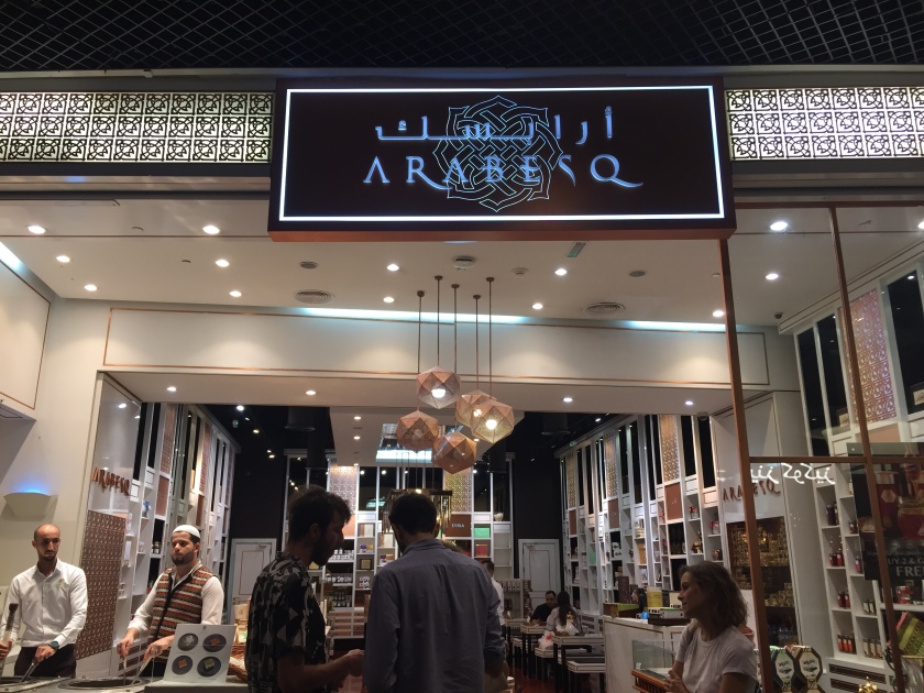
The ice cream covered with pistachio was actually quite good and refreshing.

I would have loved to check out the rest of the city, but maybe next time if a connecting flight brings us through Dubai, as I would not specifically take a trip there to spend my precious vacation days. My impression is that it’s such a built up artificial modern city with an expat majority (people from South Asia, Southeast Asia, Europeans) that, on the surface, doesn’t offer unique interests. On the other hand, I suspect Istanbul would be more interesting to explore with its old architecture and uniquely Turkish culture.
